 Planning and preparation of military operations in urban terrain can benefit from modern 3D modeling tools. These tools assist planners in evaluating various options, assessing advantages and risks, and producing tactical decision aids that improve situational awareness for the warfighters and commanders.
Modeling of urban terrain begins with mapping of the entire area. This process can use existing photogrammetric material from satellite images or aerial photos, or up-to-date information gathered during reconnaissance missions by aircraft or UAVs. Special high-resolution cameras and laser 3D terrain mapping payloads are used to collect the necessary images. During these airborne surveys, relative heights and details of features, such as windows and doors of buildings and other structures, are accurately depicted in order to enable accurate reconstruction of the buildings and surrounding terrain features in 3D perspectives. Building plans can also be used to provide interior and structural details when available.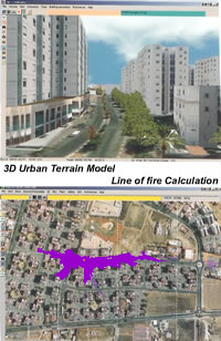
The most common method of 3D viewing uses stereoscopic image pairs, which provide an illusion of depth to allow structure height assessment. A much more realistic model can be created by computer generated 3D imaging, which can be used with “immersive virtual reality” to provide realistic views of objects from every angle.
While providing a realistic view of an area, 3D terrain models also facilitate other important functions of area analysis: automatic plotting of safe access routes, determination of visibility coverage for potential positions, options for locations of vantage points for observation or snipers, as well as allowing assessment of threats from possible enemy positions. These 3D models enable mission simulation rehearsals, detailed mission planning, effective situational assessment during the operation and detailed post mission debriefing.
Additional parts of this article:
- The Challenges of Command and Control in Urban Operations
- The urban electromagnetic environment
- Information Warfare in urban Combat
- Effects Based Operations (EBO) in urban Combat
- Situational Assessment (SA) in urban Combat
- Backing the Vigilant Eyes ISR Networking for Urban Combat
- Accelerating the kill chain Closing the Sensor-to-shooter Cycle


