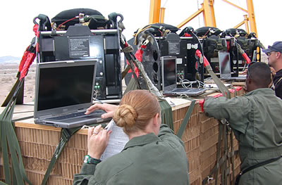
The Precision Aerial Delivery System’s Mission Planner enables aircrews to plan and initiate load release at a precise Computed Air Release Point (CARP), or within a Launch Acceptance Region (LAR), through application of accurate, Precision Aerial Delivery component modeling. The system was developed in the past six years under contract for the US Air Force, in coordination wit the US Army.
Over 60 systems have been delivered to US Air Mobility Command and other DoD units. Additional systems are in production to assist in high-altitude airdrop operations and precision personnel insertions. The model parameters include aircraft position, altitude, airspeed, heading, ground speed, course, onboard load position, roll-out/exit time, decelerator opening time, trajectory to stabilization and descent rate. Descent trajectory is calculated to each of the planned points of impact, compensated with environmental effects such as atmospheric pressure, three-dimensional wind and density information measured by dropsonde deployed from the aircraft just before the cargo.
The mission planner is used to program the drop and target altitudes, steering waypoints, wind magnitude and directions as a function of altitude, opening altitudes, and GPS “hot start” information. Mission planning is done before the flight. Information can be updated in-flight and just before the drop, from the aircraft avionics and from dropsondes and manually, using wireless link. This integrated technology allows rapid pre-flight programming and in-flight mission, threat, and terrain/environment changes for immediate reaction by the user. The mission planner uses a Panasonic CF-29 Tough Book laptop computer with specially ruggedized ‘high altitude’ hard drive.


