Miniature Video Recorders and cameras
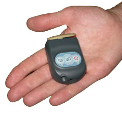
PhotoTelesis from Symetrics Industries group developed lightweight video recce system (LVRS) which is currently in service with special forces. The image acquisition and transmission device integrates image processing, storage, display, annotation and management functions. The whole system can be packed in low weight, compact system called the Military MicroRIT (MMR) or operate in a ruggedized laptop. For applications requiring covert image acquisition by even smaller systems, Sekai Electronics introduced a smaller device called MTE-100 Ultra Compact Camera Recorder. This matchbox sized miniature device provides the same image quality of the TMC-100 but has an integrated battery for 30 days standby or 3 hours continuous recording. It also supports a local area network wireless (LAN).
Panoramic Vision
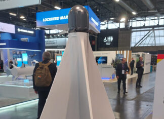
RemoteReality introduced at AUSA Winter its latest version of 360 degree visual awareness sensor, a single camera covering all directions, all the time with continuous video coverage. RemoteReality is offering its system for security systems, as well as for manned and unmanned vehicles, offering enhanced situational awareness, integration with weapon targeting and improved navigation.
Advanced Workstations for Intelligence Analysts
Lockheed Martin is promising to revolutionize the way intelligence analysts and planners see the world and work with imagery data. For image processing and exploitation at a large scale, the company is promoting its version of analyst workstations, implementing the Global Visualization Services (Global ViSe) and Analyst Roundtable. Global Vise is creating an immersive visualization tool vastly improving the understanding situations and managing operations. The system is integrating layers upon layers of discrete data in an intuitive and dynamic interface, eliminating the need to access each database individually. Users can access images, targets or reports using ‘point-and-click on geographically represented map, aerial photo or design.
Overwatch, now an established member of the Textron Systems group, is implementing its software applications with the workstations the Army is deploying for operating with the Distributed Common Ground System – Army (DCGS-A) segment of the joint DoD wide intelligence network. The U.S. Army is accelerating DCGS-A upgrades to improve the level of military intelligence support in theater. Upgrades planned within the next 24 months will streamline deployed systems with V3 configuration which will establish commonality and interoperability among analysts, focusing intelligence efforts on analytical thinking instead of repetitive data entry, and reduce training burdens by eliminating tools with similar capabilities. This version will also incorporate the AXIS Pro link analysis software from Overwatch, a new link building tool assisting analysts to discover and extract information more effectively and distribute it faster to the supported units.
SAIC is also introducing the Champion, Counter-Intelligence, Human intelligence (CI/HUMINT) advanced modernization program. While information generated by automatic or manually controlled sensors is flooding the network, HUMINT information sources are less abundant. Separating valuable information from ‘chaff’ is difficult and work intensive and most often, the flow of HUMINT slows down to a mere trickle, in contrast to the information flood coming from networked sensors. The Champion program has addresses this shortfall. While the HUMINT collection process remains unchanged, Champion optimizes the reporting of critical intelligence, by tagging and referencing the relevant elements in the reports, applying XML-tagging routines, providing geo-referencing and enabling web services. This process improves the analyst’s link to intelligence collection across the tactical level and up to the national level. The program has already demonstrated improvement in reporting capabilities with the current portal-based service providing geo-referenced visualization of the collection operations management mission. This portal is being transitioned into an operational system and is expected to become a fully integrated system next year (FY09).
Warfighters take a four-dimmensional Introductory tour of the battlespace
A different image processing system is currently in development at SAIC. The 4DAR is a photorealistic application, accurate down to the graffiti on buildings walls simultaneously presenting three-dimensional photorealistic terrain, intelligence data and time (the fourth dimension of 4DAR). The system enables soldiers to see, experience and understand their future areas of operations – from the boots on the ground perspective – even before they leave home station.
MWIR Compact Modular Imager from L3
L3 Communications developed a Compact Modular Imager (CMI) utilizing a 20µm 640×512 Indium Antimonide (InSb) Medium Wave Infrared (MWIR) focal plane array (FPA) operating in the 3.6 – 4.95 µm spectral band . To take full advantage of the new FPA, a new linear dewar cooler design was incorporated offering over 10,000 hours of operation. The sensor is mounted in a rugged open frame module enabling simple integration into multisensor payloads and weapon platforms. The sensor provides 14bit real-time digital data output at up to 60Hz frame rate and uses standard RS422 serial interface for full remote operation. According to L3 Com, higher frame rates are achieved using an addressable window mode. The FLIR has a C)2 notch filter to minimize atmospheric interference to further enhance the MWIR performance in high humidity conditions.
Laser Illuminated Cameras Extend the Soldier’s Vision
As the demand for imagery is increasing, users require better vision, from longer range under the most difficult conditions, as sensors are challenged by sharp contrasts, low light levels, obstruction and interference. As specialist in high performance digital imaging systems, Intevac Inc. is offering a line of digital image intensifiers (DI2) and laser illuminated viewing and ranging systems, addressing the needs for compact, high performance vision at the tactical level. The E3010M DI2 is a self contained sensor module specifically designed for integration into imaging systems such as head or helmet mounted displays, rifle sights and small EO/IR surveillance systems. The sensor incorporates a compact, integrated element ensemble, including an SXGA (1280×1024 pixel) electron-bombarded CMOS sensor, high voltage power supply, low voltage power supply, FLASH memory (which also contains image correction parameters). The sensor operates in the 500-900 nm band (GEN II GaAs photocathode) and has a dynamic range supporting ‘twilight to starlight’ conditions. It can also work in daylight condition while the high voltage is switched off, operating in the Near IR (NIR) band.

Intevac is also introducing the Laser Illuminated Viewing And Ranging (LIVAR) – Short Wave IR (SWIR) based cameras, integrated with a laser illuminator to form a long-range viewing and ranging system, that can work in parallel t a FLIR device. SWIR sensors can effectively penetrate battlefield osbcurants, windshields and windows, in day and night, overcoming many of the limitations that earlier systems demonstrated when operating in asymmetric warfare scenarios. In an integrated FLIR/SWIR/LIVAR system, the FLIR is used as the primary sensor for threat detection, spotting a potential target at long range. As the target gets within the LIVAR range, the system sets the gate range for target location and then provides high-resolution digital stream of images for positive combat identification Using range-gated laser illumination, the system contributes to positive stand-off combat identification and high resolution imagery.
The laser operates in ‘eyesafe’ wavelength band. LIVAR 500 is designed as a compact integrated sensor, for integration in mounted or dismounted applications. The LIVAR 500 uses a TE Photocathode (EBCMOS) focal plane array with 640×480 element matrix with spectral response range of 950-1650 nm.
 Medium Range EO Infrared sensor System (MREO) for FCS Vehicles
The Medium Range EO Infrared sensor System (MREO) will be used on the manned combat system (MCS) and Infantry Carrier Vehicle (ICV), as well as the armed robotic vehicle – assault light (ARV-A-L) unmanned system. It will provide the ‘eyes’ of the ground-based platform. This stabilized, day/night networked multi-sensor includes a mid-wave thermal imager (MWIR), color/low-light TV and laser illuminated imager. The MWIR sensor is based on L3 communications’ 640×512 matrix, 20 micron dual-aperture IR camera. The system has a three-axis stabilization in pitch, roll and yaw, maintaining stable line of sight while on the move, or when elevated on a mast, remotely controlled by the crew or via the vehicle’s network communications, by external platforms or dismounted soldiers. The operator can control the system manually, as imagery from the sensor, with video from color daylight or low-light video monitored on the vehicle’s user screens. The image is presented in high resolution over a panoramic, medium/narrow and super narrow FOV.
The multifunction laser can assists the crew in long range target identification (supported MWIR laser gated imaging). As a multi-function laser it also provides rangefinding and target designation; the system provides far target locations (FTL) of all targets tracked by the system. It provides target location and designation for on-board weapons as well as external effects. In an automatic mode the system feeds the thermal and visible imagery to the automatic aided target recognition (AiTR) processor, which classifies and prioritizes the imagery to highlight multiple air and ground targets, discriminated and tracked under all weather and visibility conditions. The MREO sensor can be mounted on the turret surface or elevated on a telescopic mast.
Being part of the planned 2nd and 3rd ‘SpinOut’ phases, MREO is expected to become a standard sensor package to be fielded throughout the U.S. Army’s tactical mobile units in the next decade. The system uses the modular, miniaturized Common Electro-Optical Electronics Unit (CEEU) for image processing and control. This COTS based processor provides automatic tracking, interface the sensor, vehicle’s systems and on-board C4ISR systems, range, positioning and geo-location, as well as image recording, storage and distribution services. Another module, handling the systems power intensive functions is the power and servo controller.

Additional articles in this review:
- AUSA Winter Exhibition Review 2008
- Armored Vehicles at AUSA Winter 2008
- Hightech Gear for the Dismounted Warfighter
- Defense Electronics at AUSA Winter 2008
- Scalable Response Means More Choices for the Warfighters
- Tactical Image and Intelligence Exploitation Systems
- Joint Heavy Lift (JHL)


