After the successful fielding of the Command Post of the Future (CPOF) with brigades and battalions, formally integrated into the Army Battle Command System (ABCS) DARPA aims lower, at the platoon level and below, providing warfighters with internet-style tools for mission planning, post mission debriefing and situational understanding.
Handling the masses of data and imagery streaming from the field, new tools are being fielded to assist battalions, companies and platoons to obtain, process and exploit intelligence and operationally relevant information. Such systems streamline, automate, and simplify tasks undertaken by ordinary soldiers and officers, transforming every staff member and Non Commissioned Officer (NCO) to an expert. One such application, developed under the DARPA Tactical Ground Reporting System (TIGR) program is designed to automate intelligence collection and reporting at the company and platoon.

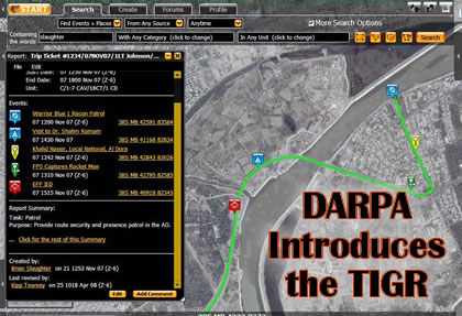
TIGR is a map-based reporting system enabling users to store and retrieve voice recordings, digital photos, GPS tracks. By the user defining the area of interest, the TIGR pulls all relevant data available in local and remote servers linked to the system – much like a search on the internet, cross-referencing between Google Earth and Wikipedia. TIGR retrieves event reports, intelligence vignettes, images, patrol debriefs etc. It also assists filing of reports in and after a patrol, by associating each element with its geographic location. As a networked system, TIGR accesses many servers over the military global information grid, enabling users to receive information from multiple sources, and understand the context of local events within the ‘big picture’.
The system is designed primarily for counterinsurgency operations, enabling collection and dissemination of fine-grained intelligence on people, places, insurgent activity and understanding the ‘human terrain’. Another advantage of the system is TIGR is tracking dynamic changes of terrain with the system – as the data used by the system is dynamically updated, showing new structures being constructed, destroyed bridges or obstacles that appeared overnight. TIGR manages this dynamic tactical landscape using before/after photos and updated imagery to provide an up-to-date view of the battlespace.


