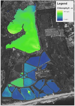
 A hyperspectral (HS) intelligence payload system known as ‘Chariot of Fire’ was developed by Elbit Systems Electro Optical subsidiary El-Op. The system is currently deployed on aircraft or UAVs but could be enhanced in the future to support satellite platforms. As a dual-use payload, the ‘Chariot’ has already been deployed in Israel and abroad on various missions, such as tracking uranium contamination from mining activity, oil spills and monitoring efficiency and spillage from water treatment facilities. ElOp is already developing a multi-spectral imaging sensor for a satellite under the French-Israeli VeNUS program.
Hyperspectral data is useful in a wide variety of applications relating to the classification or identification of properties of objects with high precision and resolution. Elbit Systems’ Electro-optics Elop has been assigned by the Israeli government as a national center of excellence for this field. The current technological solutions are focused on HS airborne sensors employing continuous sensing through multiple, very narrow spectral bands covering Visual, Near Infra-Red (VNIR) and Short Wave Infra-Red (SWIR) domains (0.4-2.5 micron).
Hyperspectral sensing has many military applications in Measurement and Signature Intelligence (MASINT). Many such applications are also relevant to commercial uses, positioning these instruments as dual-use sensors. For example, environmental mapping of aquatic areas, or monitoring pollution levels (see photo above left), in the civil applications, could translate into tracing specific chemicals related to Weapons of Mass Destruction (WMD). Geologic mineral mapping could translate in the military to tracking of underground activity. Agriculture applications like precision farming, growth monitoring, yield prediction, and soil classification are paralleled in the military world as identification of weapon caches, fortification, mining, camouflage discrimination, terrain and mobility assessment, etc.
 The payload (seen in a bottom view on the left) includes a special purpose hyperspectral camera integrating multiple sensors simultaneously gathering reflected radiation in 215 spectral bands in the 0.35 – 2.5 nm range. The camera is fitted with on-board GPS/INS sensor providing geo-referencing for every pixel. The payload also includes a panchromatic imaging system providing high resolution coverage of the area under surveillance. The HS sensor’s resolution is two meters. The new payload has an aerial coverage capacity of 100 square kilometers per hour and would typically operate in daylight, for about eight hours. The operational concept calls for flight to the target at night, and data collection during daylight hours. Designed for operation at altitudes up to 25,000 meters, at a velocity of up to 120 knots, clearly indicating a usage profile of a high flying UAV.
The ‘Chariot’ operates fully autonomously, following a mission defined at the ground control segment. The sensor will follow a pattern visiting specific points of interest, following the flight course and camera angles defined by the mission plan. In Operators determine the targets for visit, the spectral bands recorded, data collection and integration schedules. The data collected automatically processed by the system include a Digital Surface Model (DSM) map, aerial photo and thematic maps. To process the map within reasonable time, the ground segment utilizes a 16 core processor, 10 terabyte of memory and geographical database (GIS) server, feeding multiple mission operators workstations.
Related Item: Israel’s Next Generation Spy Satellite could be Operational by Late 2012


