Updated satellite images taken by Imagesat Eros B intelligence satellite acquired by ISI on 14/2/16 reveal a deployment of Chinese HQ-9 (the Chinese S-300 equivalent) Surface to Air Missile (SAM) system now positioned in ‘Woody Island’, previous images obtained by the same source on February 3, 2016 did not show presence of such weapons on the island.
This deployment is likely the first Chinese deployment of heavy SAM system in the spratly (paracel) archipelago in the South China Sea – an area of many island and atolls claimed by China, Taiwan, Vietnam, Philippines, Malaysia and Indonesia. The Woody Island claimed by Vietnam, was seized by China in 1974.
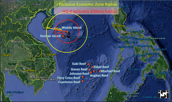
Using it’s very high resolution satellite, ISI Analysis team has identified the SAM systems with high confidence as the HQ-9 system. With an operational range of 200 km at high altitude, the HQ-9 pose a threat to military and civilian air traffic.
The high resolution image and shadows casted by the tall erected launchers clearly show four ready to launch missile tubes and six additional missile carriers. However, the radar system providing target acquisition for the unit was still folded, ISI analysts noticed.
The linear deployment along the beach seems to be temporary, either a s part of a drill or prior to more permanent preparation of launch pads, paved roads and bunkers protecting these strategic assets. Further deployment or these assets on the island, or redeployment of the SAM battalion back to the mainland will determine the Chinese intentions.
The missiles cover a significant part of the Economic Exclusion Zone (EEZ) around the island, and enforcing the claimed Air Defense Identification Zone (ADIZ) which was another disputed issue among the nations.
Both US and Taiwanese sources confirmed the information.