The Pentagon is harnessing its strategic missile warning system to conduct surveillance on a global scale, improving strategic situational awareness over the entire planet. A new Battlespace Awareness Center (OBA) that came online last month processes massive streams of satellite infrared immagery, generating Overhead Persistent Infrared (OPIR) that turns the pentagon’s ‘Space-Based Infra-Red Systems’ (SBIRS) into an all-seeing, unblinking eye.
This sophisticated and mostly classified satellite system is now proving to be a valuable intelligence asset in monitoring and supporting combat operations in remote theaters, where U.S. forces are involved – directly and indirectly. North Korea, Iraq, Syria, Libya, Yemen, Central and East Africa or Ukraine are only few of the hotspots such surveillance capabilities could make an effect.
Besides the detection of intercontinental ballistic missiles, the ultra sensitive infrared sensors operating on board SBIRS satellites are able to pick up the heat signatures of small explosions, large fires, and other signs of mass human activity – ranging from forest fires and factory explosions through to the clearing of crops and trees and conventional military conflict.

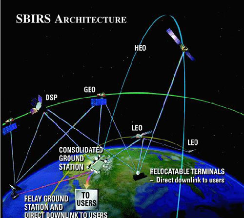
SBIRS is a constellation of geostationary and high elliptical orbit strategic surveillance satellites originally designed to spot launch events of ballistic missiles. The primary role of these satellites is to detect a launch, identify what kind of missile or rocket was fired, determine its trajectory and, if necessary, cue a missile intercept. Air Force officials are careful not to describe the exact capabilities of OPIR, but current satellites’ sensors reportedly detect ‘significant heat event.’ by the hour. Each event represents a missile or rocket launch, or significant explosions. These strategic surveillance assets are enhancing combatant commanders with battlespace awareness by detecting non-launch-related infrared events.
The OBA that came online last month is operated by the U.S. Air Force’s Space and Missile Systems Center (SMC) and the 460th Space Wing at Buckley AFB in Aurora, Colorado, operates the SBIRS system. According to air force officials, In just a few months of operation, this multi-organizational center has improved missile warning mission and led to advances in surveillance and battlespace awareness operations in support of combatant commanders.
“The SBIRS sensors are the most capable infrared that we have ever produced,” said Colonel David Miller, U.S. Air Force, commander of Air Force Space Command’s 460th Space Wing. Each SBIRS GEO satellite in geosynchronous orbit has two main sensors: one that scans large areas and one that maintains constant surveillance of smaller areas to provide more timely warning of missile launches. In addition, legacy DSP satellites scan the globe once every 10 seconds. Air Force officials say SBIRS is even faster. “Our unique attribute is persistent global surveillance”, Miller noted, “the sensors provide an ‘unblinking eye’ that provide surveillance and warning of threats to the U.S. embassy and U.S. forces in Iraq.”
Lockheed Martin Space Systems Company, Sunnyvale, California, is the SBIRS prime contractor, and Northrop Grumman Electronic Systems, Azusa, California, is the payload integrator.
Current satellite-based missile warning capabilities evolved from the Defense Support Satellite (DSP) program of the 1970s. The capability gaps realized during the 1991 Persian Gulf War, after Iraqi short-range missiles were used against Saudi Arabia and Israel drove the U.S. Department of Defense (DOD) to expand theater missile warning capabilities. DSP was never designed to spot short-range missile launches, but follow-on sensors improved imaging capabilities to deliver timely warning of such events.
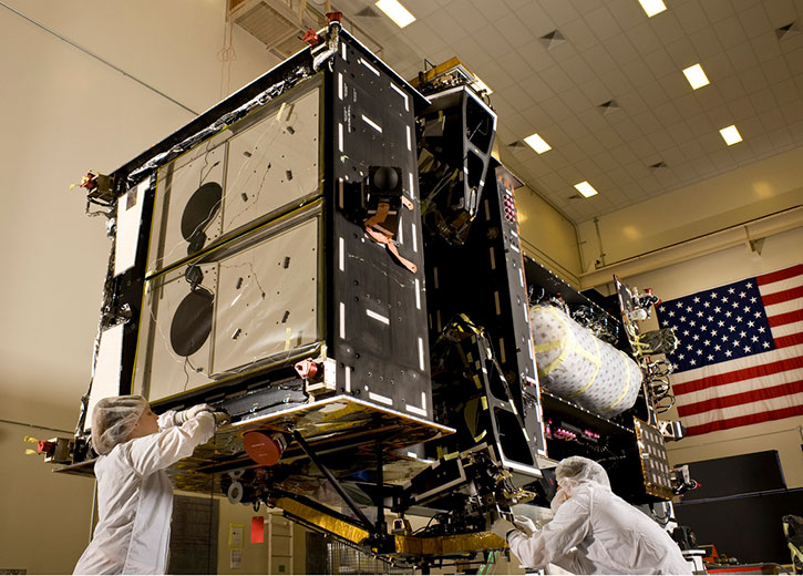
The SBIRS constellation is currently comprised of two satellites in geosynchronous orbits (GEO) and two payloads hosted on classified satellites in high elliptical orbits (HEO), providing infrared signatures of heat events across the world. These assets provide the primary and earliest means strategic early warning of missile launch events, covering countries like China, Russia, Iran, and North Korea. SBIRS satellites carry infrared sensors designed to detect ballistic missile launches. The sensitive detectors can instantly spot missile launches using the heat emanating from a missile’s engine as it launches from its silo or launch-pad. Upon detection, SBIRS sends that data to the ground-based processing center, where it is correlated with other data to plot exact position of the launch, type of threat and likely trajectory of the missile, thus providing early warning and targeting data for further action and response. Four new SBIRS satellites are currently in preparation – two are already produced and awaiting deployment to space and the other two are in production.


