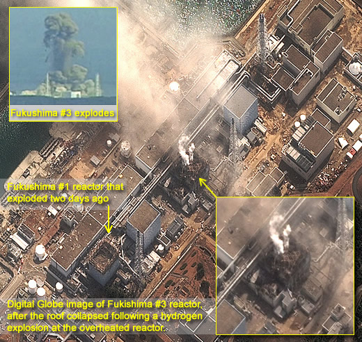
As Japan copes with the aftermath of the 8.9 magnitude earthquake and tsunami that struck March 11, earth reconnaissance satellites and aerial reconnaissance aircraft and unmanned vehicles are deployed to the area in an effort to assist emergency operations with up-to-date situational assessment and efficient response to the events of the highest priority.

Satellite imagery providers Digital Globe and Imagesat have released today updated images from the disaster area, showing the unprecedented scale of devastation.


In addition to imagery acquired by satellites aerial manned and unmanned ISR systems dispatched to the area in support of the relief operations include the U-2 high-altitude, all-weather surveillance and reconnaissance aircraft from the 5th Reconnaissance Squadron here and RQ-4 Global Hawk remotely piloted aircraft from the 9th Operations Group’s Detachment 3 at Andersen Air Force Base, Guam. The U-2 has been deployed to capture high-resolution, broad-area synoptic imagery, by using an optical bar camera producing traditional film products which are developed and analyzed after landing. Once the aircraft returns with the film, it will be shipped to Beale AFB, Calif., where experts with the 9th Intelligence Squadron will process and analyze the 10,500 feet of film.
“The broad, synoptic collection of large land mass and littorals are of great benefit to decision makers,” said Lt. Col. Spencer Thomas, the 5th RS commander. “It will aid them in determining locations and extent of damage the earthquake and tsunami have left.” From start to finish, the mission is expected to take four to five days.


