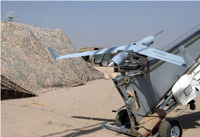
The ScanEagle Unmanned Aerial Vehicle (UAV) is a 40 lbs (18 kg) UAV designed for continuous mission of 15+ hours, cruising at speed of 50 kt at an altitude of 5,000m’. The system was designed for autonomous field operation. ScanEagle carries a payload of 6 kg, operating at a ceiling of 5,000 m’. It can be launched and retrieved over any terrain, including naval operations.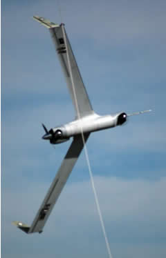
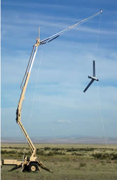
The system includes a UAV, a Sky Wedge hydraulic launcher, Sky Hook retrieving system, and mobile ground control element. The UAV is equipped with nose-mounted inertial-stabilized camera turret, designed to track an object of interest for extended periods of time. The gimbal carries either zoom CCD or IR sensor. Maximum level sped is 70 kt. ScanEagle is currently deployed with the US Marine Corps in Iraq, where the system flew over 4000 hours this by July 2005.
 ScanEagle was designed with removable avionics bay and two expansion slots allowing seamless payload integration. An enhanced ScanEagle was introduced by Insitu in August 2006, incorporating a redesigned camera turret, enhanced infrared camera, and Mode C transponder. The camera turret, utilizes the inertially stabilized turret introduced in 2003, but will not require electronic stabilization by software at the ground station. This will enable utilization of images via Rover type systems. The new turret will be able to house larger cameras, which provides more options on payload camera integration.
In August 2006 Insitu has incorporated various new systems under the These changes are currently included in the Block D upgrades program These include the DRS Technologies E6000 infrared camera, improving the UAV’s capabilities from a 320×240 pixel resolution fixed camera with an 18-degree field of view to a 640×480 camera, with an increased resolution that supports a digital zoom view of 7.5 degrees. A new inertially stabilized turret, offering a factor of 5 improvement in disturbance rejection has also been introduced. Custom designed, ultra-light Mode C Transponder, is also becoming a standard issue on the ScanEagle. THis transponder is programmable during flight and, as such, allows the vehicle to become stealthy as necessary even at low altitudes. This capability will help with aircraft deconfliction within Operation Iraqi Freedom but will also enable easier integration of the system into applications within the National Airspace or civilian applications. Other changes include the introduction of video transmitter system, Rover interoperability and in-flight fuel measurement systems as well as a number of improvements for reliability and modularity.
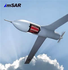 A Block D prototype was recently tested in a basic configuration, flying on a continuous, 22 hour mission. The company also announced cooperation with ImSAR, for the development of a new micro SAR prototype which could be introduced with the ScanEagle in the future.
The Block D changes incorporate multiple product enhancements including a new improved IR (infrared) camera with a factor of 3 improvement in the resolution; a new inertially stabilized turret with a factor of 5 improvement in disturbance rejection; a custom, ultra-light, Mode C transponder to facilitate airspace deconfliction; new video transmitter system; Rover interoperability; in-flight fuel measurement systems; and numerous improvements for reliability and modularity.
In early January 2007 Boeing Australia Limited announced it has been awarded a contract to provide reconnaissance and surveillance services to the Australian Army using the ScanEagle autonomous unmanned aerial vehicle (UAV). The services provided by ScanEagle are currently being used in southern Iraq by Australian soldiers operating with the Overwatch Battle Group (West)-2 in Operation Catalyst. By June 2007, the operation was expanded for six months, to support te Australian troops deployed in Afghanistan under a A$20 million program.
In February 2007 the ScanEagle UAV system has been qualified to comply with NATO mandated unmanned aerial vehicle (UAV) interoperability standard (known as STANAG 4586), establishing common specifications employed in ground station system operating all UAVs used by NATO military forces. STANAG compliance will enable existing and future deployed ScanEagles to be operated with operational ground control stations such as Army One as well as other STANAG qualified systems operated by NATO member nations. The ScanEagle Vehicle Specific Module and Multiple UAV Software Environment ground station were integrated with the Common UAV Control Software package developed by CDL Systems Ltd. employed with the “Army One” ground control station. During the three hour test flight, the ScanEagle team achieved Level 2 for the UAV and sensor system; Level 3 for the onboard electro-optical camera and sensor system; and Level 4 for the UAV and payload control. Further tests employing multiple ScanEagles and ground control stations are scheduled to validate various autonomous functions.

