Early strike missions employed laser-guided weapons exclusively, and required the launching platform, or advanced target designation parties on the ground, to maintain constant line-of-sight, to designate the target by laser from relatively short range. What made such attack mission even more effective, was the ability to share imagery from the UAV with ground forces, coordinating an attack through a ‘short cycle’, rather than through a central command, control and coordination facility. This generally slows the process by guiding it through target-location ‘mensurating’ procedure, verifying that the target coordinate are at the highest accuracy, and that friendly forces, or non combatants are not at risk. This process is critical when UAVs are operating alone over hostile territory. However, when operating in support of ground forces, drones are normaly employed as part of the ground force and should be subject to the same checks and balances guiding the use of other weapons.
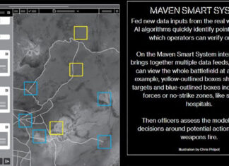
A key element in the air-ground employment of drones, is the video datalink, streaming live video from the airborne EO payload on drone, to the supported unit on the ground below. While early versions supported ‘one way’ communications, more advanced models currently offer full duplex, providing the commander on the ground full control of the payload. Geo-referenced video images establish a common language, offering ground commanders an elevated view of their surroundings, gaining better situational understanding and clear view of evolving situations, potential opportunities or imminent new threats. Geo-referenced images also provide for simpler and intuitive orientation, enabling the user to rapidly ‘hand off’ the target to the UAV operator, who then ‘takes control’ to pursue the final strike immediately, once attack permission is granted. Such a language is also effective in resolving potential fratricide situations or identification errors that might appear, when pilots or UAV payload operators ‘walk through’ radio communications, to orientate, locate, identify and verify a target requested by the ground element. A two-way datalink capable in transferring coordinates and images between terminals saves time and errors, thus dramatically shortening ‘sensor to shooter’ cycles.
Although unmanned aircraft are performing well on armed reconnaissance missions, none of these were actually designed for such missions from the start. Therefore, compromises have been made in mission-performance, flight altitude, mission endurance and area coverage, to provide for such missions.
Read the other parts in this series:
- Miniaturizing the Aerial Weapons
- New Language for Air-Ground Collaboration
- UAVs as Multi-Mission Warfighters
- Arming the Shadows
- Suicide Micro-UAVs

