An operational planning tool, intended to support Military Operations on Urban terrain (MOUT), was developed by General Dynamics for the / US Army Topographic Engineering Center. Dubbed Urban Tactical Planner (UTP) it provides decision support tools for planning of complex operations in urban terrain, and Military Operations Other Than War (MOOTW). The system enables clear visualization of the terrain and assessment of threat capabilities based on advanced visualization, modeling and terrain analysis. UTP can be operated at all levels, from highest command levels down to the squad.
The tools loaded to UTP facilitate rapid visualization of key aspects of the urban environment, including buildings, roads, railroads, streams, forests, marshes, water bodies and vertical obstructions. The system groups the urban features by forming Builtup Area Terrain Zones, (BTZ)s, which can be superimposed on high-resolution terrain images, raster maps, elevation and vector data layers.
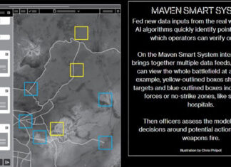
UTP provides 2D map, 2D imagery, 3D visualization of key aspects of urban environment, based on elevation data and perspective views. Information can be presented in multiple layers in any combination. Tabular data can be attached to show building data, vertical obstruction heights, road types, bridge data etc, intelligence photos, video clips etc. Such information can be presented by clicking on the object of interest. Planning products can be distributed in Arcview Geographic Information System (GIS) format over CDs and DVDs, or other wireless broadband communications formats.


