With the successful launch Monday, June 11, 2007 of its Ofeq-7 imaging satellite, Israel sustained its essential intelligence asset for any war contingency. According to Israel’s Ministry of Defense, the new satellite was launched westward over the Mediterranean by the local-made Shavit three-stage solid fuel vehicle from the Palmachim aerospace base at 02:15 IT, June 11. The first images from space should be received within 24 to 72 hours from launch. The launching sequence was monitored under strict secrecy, but with growing tension by the ground crew, which had witnessed the failure of the Ofeq-6 launch, was destroyed on Monday 6 September 2004, when the third stage of the Shavit rocket launching malfunctioned a few minutes after launch.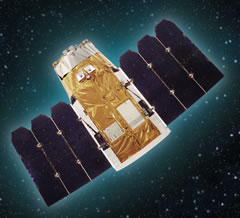
Once firmly deployed in space and functioning, Ofeq-7 will join its aging predecessor, Ofeq-5, still functioning in orbit, one year beyond its expected life span. Analysts claim, that the new satellite will fill the gap in covering long-distant areas, rendering real-time intelligence on high priority targets, such as Iran. Weighing 300 kilograms, the Ofek 7 will orbit earth from up to 600 kilometers in space. It has a minimum lifespan of four-years. Like its predecessors, Ofeq-7 will be able to store images taken during its flight and download them via downlink when flying over the IAI-run ground station.
 The Ministry of Defense’s (MoD’s) intensified space drive comes amid increasing concern here about Iran’s nuclear development program, Syria’s contradictory intimations toward peace talks or war, and the support both nations provide to Hizbollah, Hamas and other designated terrorist groups. Three of the new imaging satellites – Ofeq-7, the TechSAR radar satellite and the planned Ofeq-8 – have been on the MoD manifest for years. Satellite imaging services are also available from Imagesat International, a Cyprus-based joint venture company partly owned by IAI, offering services of the Eros A and Eros B satellites which are also based on Ofeq technology. According to foreign sources, the Israel Ministry of Defense has acquired exclusive rights to the satellite’s photographs of Middle Eastern countries. But sources here said heightened regional tensions have already compelled near-term, multiyear funding for at least one additional spacecraft, dubbed Ofeq-Next. Moreover, the MoD plans to enter into a partnership with Spacecom, based here, so that the planned Amos-4 multiband communications satellite will serve the commercial market as well as military needs, reports close to MOD sources indicate.
While refusing to divulge detailed performance data of the new satellite, defense officials claim that Ofeq-7 has by far the most advanced satellite Israel has sofar launched into space. Officials said that it was superior to the Eros B satellite – launched in April 2006 – which has the ability to spot images on the ground as small as 70 centimeters. The officials refused to give exact data as to what this superiority means. “With this launch we have improved Israel’s operational capabilities by dozens of percent,” said Brig.-Gen. Haim Eshet, director of Space Programming at the MOD’s Defense Research and Development Directorate (DRDD). “This is due to the improvements made to the satellite and also since we now have better coverage in the skies.”
Israel has accelerated its activities in space reconnaissance since the Steinitz Knesset committee on Israeli investigating intelligence in advance of the 2003 war in Iraq mentioned the crucial contribution of satellite imagery to reliable intelligence, and included a recommendation “to expedite Israel’s espionage satellite development as a long-term visual intelligence infrastructure in the regional strategic balance”.
 One of the prime targets for Israel’s space intelligence is the growing threat posed by the Tehran regime, which has increased recently, with President Mahmoud Ahmadinejad’s defiant speech. Israeli military intelligence has placed highest priority on detailed monitoring of Iranian efforts to obtain chemical, biological, and nuclear weapons, as well as long-range delivery systems and high resolution imagery has become one of its major intelligence and reconnaissance assets.
Some of the known technologies involved include Multi-spectral imagery, which can take images in different wavelengths, including color. Analysis of images at different wavelengths can indicate the presence of hidden objects. El-Op, the payload developer is also working on a hyperspectral imaging sensor which will have a larger spectral band yielding even more imaging data. Ofeq-7 is based on the IAI’s OPSAT 2000 design (shown on the top of this page). IAI is already working on its new OPSAT 3000 design (the satellite is shown in the photo above and a model depicted at the bottom of this page), utilizing IAI common bus (also employed for the Tecsar and Eros C). This bus will support a new telescope, yielding greatly improved imaging without significantly increasing the weight of the spacecraft. It will employ PAN (pancromatic) and multi-spectral (MS) imaging cameras, sharing a common optical assembly and capable of simultaneous operation, including PAN-sharpening functions.

IAI is also planning to launch the TECSAR satellite (pictured above) , equipped with new synthetic aperture radar developed by Elta. This satellite is scheduled for launch with an Indian launch vehicle during this summer. It will provide Israel with all weather, day and night high resolution radar imaging capability.
But Israel is not alone in its space activities. In fact, Space has become an integral component of modern military planning and the Middle East is no exception to its ambitious quest in space. For a related analysis – read Iran Challenges Israel’s domination of the ‘high ground’ of Space – by David Eshel


