Saturday, May 18, 2024
More
    Home Blog Page 424

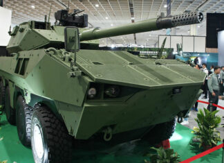
    Integrated Systems for AFVs

    Tight integration between sensors, weapon systems and command levels is already reflected throughout all levels of the Israel Defense Forces. The armor and mechanized units are receiving elements of “Battle Management Systems” (BMS). These units developed by Elbit Systems, integrate the vehicle’s sensors such as tank commander’s thermal sights, navigation and communications systems. The sight images, viewed by the tank commander, can be transmitted and shared by other crew members of his unit, as well as by commanders at higher echelons.

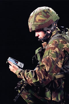
    Elevated views of the area, as captured by a UAV, and other elevated sensors can also be shared by all units, equipped with Tadiran Spectralink’s vehicular Tactical Video Receiver (V-TVR). The user can tune into the channel of a specific sensor, presenting the video and telemetry on the vehicle’s digital display. Similar equipment is used by helicopter pilots, to receive UAV sensor data directly from the UAVs, en-route to their target. Similar devices are also provided to dismounted commanders, equipped with the V-Rambo kit – comprising miniature receiver, and wrist display.

     < page 5 out of 10 > Start – Previous –  Next

    Panoramic IR Scanners & Stand-Off Measures

    Start < Page 4 of 9 >

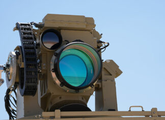
    Automatic infrared systems can augment, and sometime replace radars in certain missions. Typical systems are the ADIR, from Elbit Systems and Spider or CEDAR from Controp. Such systems are comprised of a FLIR installed on a rotating plate, scanning a sector of up to 180 degrees, detecting suspicious targets, tracking them and triggering alerts after targets are identified as hostile. The system can track suspicious targets without setting an alarm, until their behavior becomes threatening or as they enter a high security zone, thus enabling effective operation in populated areas. The main advantage such system has over radar is the fact that it actually produces an image, for alarm verification.

    Stand off Countermeasures:

    Even when an effective sterile buffer zone is established between the forces and the surrounding inhabitants, troops must maintain close contact with the population on checkpoints, roadblocks etc. Utilizing advanced technology, such contact can now be initiated at extended range, enhancing the protection of soldiers while also improving cross-language communication. Utilizing the Long Range Acoustic Device (LARD), troops can issue a verbal challenge with instructions at a distance in excess of 500 meters. In Iraq and Afghanistan, LARD systems are integrated with the Phraselator vocal translator, to transmit hundreds of messages in Arabic, and Afghan Pashtu languages. LARD employs directed acoustic signals to which enable troops to communicate over an acoustic beam 15-30 degrees wide, transmitting clear voice or other audible signals.

    Non-lethal weapon systems can be employed in the “sterile” zone, to act as early warning and deter innocent people from entering the restricted area. Non lethal area denial weapons are ranging from sticky or slippery foams and liquids, eliminating movement within buildings, or streets, to stun guns and electronic shock inducers, used to immobilize vehicle’s electrical systems. Two of the most recent area denial systems are the M-5 Modular Crowd Control Munition (MCCM) and Taser Anti-Personal Munition (TAPM) both are a less than lethal mines, MCCM is loaded with rubber balls instead of steel pellets exploding when triggered by tripwire or sensor input. TAPM uses Taser electrical shock devices and can disable any human target by remote control or self activation. Such devices are used to deter, disorient and temporarily incapacitate assailants, separating them from innocent bystanders. Further into the future, troops could utilize Active denial System (ADS) directed energy non-lethal weapon system developed by Raytheon for the Air Force Research Labs. ADS projects a focused millimeter wave energy beam which induces intolerable heating sensation on an adversary’s skin and cause that individual to be repelled without injury. ADS could be used to stop, deter and repel hostile elements without applying of lethal force.

    Additional parts of this article:

    Security Applications of Ground Surveillance Radars

    Start < Page 3 of 9 >

    Typical military radars which can be employed for such missions include the Thales RB-12, Elta MDSR (EL/M-2129) or PPS-5 (currently enhanced by Syracuse Research Corporation into the PPS-5D version). These systems are capable of detecting a human target at a distance of 3-10 km. Airborne threats (such as ULM or UAVs) can be spotted at long distance, while vehicles can be detected and tracked at a distance of 10 – 20 km. Due to their high sensitivity and wide area coverage, these radars usually generate substantial “noise”, especially when operating adjacent to populated areas. To reduce such noise, radars are optimized to cover shorter ranges, and implement special filtering algorithms which improve their performance in force protection roles.

    Motorola Perimeter Surveillance Radar System (PSRS) and EL/M-2128 MINDER from Elta are two examples of such radars – they are designed to operate under all weather conditions, spot movement at short distances of up to 1,000 meters from a fence and trigger an instantaneous alarm including location, bearing and distance of the target. Perimeter Surveillance Radar System (PSRS) is a compact ground based radar designed by Motorola Israel for detection of human and vehicular targets, at a short distance from the fence. Modern radars can link directly to digital maps and geographical databases, feeding target data directly into net-centric tactical command systems.

    Plextek is offering the BLightER electronically scanned surveillance radar capable of detecting human targets at ranges from 50 meters up to 5 km. The BLightER 200 uses static antenna covers an arc of 80 degrees BLightER uses a wireless network to automatically linking with neighboring radars and command centers. When security coverage of a large area is required, aerostats are providing an effective solution – medium size aerostats with volumes of 50 – 35 cubic meters can lift electro-optical, radar and ESM sensors for extended durations, and provide continuous coverage of wide area, at ranges of several kilometers around the site. Typical aerostat borne systems are TAOS and Mini-TAOS, produced by RAFAEL. Larger aerostats such as JLENS, by Raytheon extend ground and air defense capability to protect from cruise missile attacks.

    Additional parts of this article:

    Wireless Data Communications

    One of the main challenges which surfaced in recent conflicts in Israel and Iraq is the shortage of bandwidth, particularly in frequencies allocated for datalinks (video and telemetry communications). New systems are already maturing, with the introduction of enhancements for current VHF and UHF communications systems, introduction of digital datalinks and utilization of existing infrastructure such as commercial and military cellular networks.

    One of the primary efforts is to extract maximum data transfer capability available with existing communications links. This effort has already paid-off with excellent results, through enhancement of data-communications capability of Tadiran Communications’ CNR-9000 family of manpack and vehicular radios. The current version, CNR-9000 HDR unit can transfer 115 KBps over standard 25Khz spaced VHF tactical radio channels. Tadiran achieved this capability, considered to be the highest data rate over standard VHF channel on the market, through the use of advanced digital processing algorithms implemented into the current set, designed as a Software Defined Radio (SDR).

    IAI/Elta is demonstrating their EL/S-8018B Data & Image Exchange Unit (DIDU) at LIC-2005 which facilitates data and high quality image transfer over standard VHF tactical radios. When video transfer is concerned, bandwidth restrictions become even more critical, requiring special compression to facilitate improved quality video exchange.

    Visual Defense, a member of Emblaze Systems group which offers video transfer technology developed for commercial 3G cellular phones. The same technology facilitates video archiving and distribution over existing channels, as narrow as 10kbps, over TETRA (such as the Motorola communication’s Mountain Rose (cellular tactical network recently fielded by the IDF), and commercial GSM and GPRS cellular networks.

    Tadiran Spectralink has fielded other technologies to address the datalinks bandwidth allocation challenge. The company’s StarLink family of miniature datalinks is designed to facilitate digital communications of video, data and telemetry, over a narrow bandwidth (up to a factor of 10 compared to existing datalinks). The datalink is designed for the new generation of miniature UAVs, which will be fielded in large numbers by small infantry units and Special Forces teams.

    < page 3 out of 10 > Start – Previous –  Next

    Terrain modeling and tactical decision support systems

    Most of the current Low Intensity Conflict (LIC) operations between the Palestinians and Israelis over the occupied territories in the Gaza Strip and West Bank are taking place in densely built-up environment. This type of terrain is favorable for urban guerilla warfare, and poses tough challenges for the deployment of regular military forces.

    Having to engage the enemy in such terrain, the Israel Defense Forces (IDF) developed unique urban combat effects based capabilities which enabling forces to localize effects on the target, while minimizing collateral damage to surrounding area, friendly forces and non-combatant population. Based on experience gathered during operations in Jenin and especially in its refugee camps in 2003, the IDF is examining several systems which will enhance terrain and situational assessment, planning and tracking of complex urban operations. A typical system is the DTACT developed by IAI/MLM for situational awareness, operational planning, simulation and mission rehearsal.

    Such systems are based on advanced simulation tools, including Tiltan Systems’ T-View 3D terrain model enabling commanders to plan, track and assess the situation on a detailed 3D representation of a complex urban terrain, including thousands of geo-specific structures. The system provides commanders at different levels and locations capabilities to share a common visualization of an area, simultaneous to the same viewpoint as seen by each combat element. Tiltan also offers the ArenaViewer produces an interactive visualization of the battlespace created from real-time imagery and video feeds overlayed on 3D terrain and fused with geo-referenced data layers. ArenaViewer simplifies access to multiple sensor and data layers via existing low bandwidth communications channels.

    < page 2 out of 10 > Start  –  Next

    Mosquito Micro UAV

    Mosquito 1
    Mosquito 1
    Mosquito 1.5 micro UAV

    The Mosquito 1 is a micro UAV designed by Israel Aircraft Industries, in response to the Israel MOD Defense Research & Development Directorate (DRDD) micro systems technology development. First flight was performed on January 1, 2003. The miniature saucer shaped plane weighs 250 gram and as a wing span of about 30 cm. The vehicle carries a miniature video camera and already performed several flights with up to 40 minutes endurance each. The Mosquito is launched by hand and lands on its skids at the end of its mission.

    The company is planning to test the advanced Mosquito 1.5 version soon. This improved design will weigh twice the Mosquito 1 weight, will be capable of flying a 60 minute mission with enhanced video camera (two gimbals provide roll control with electronic image stabilization), and carry improved avionics, enabling fully autonomous missions.

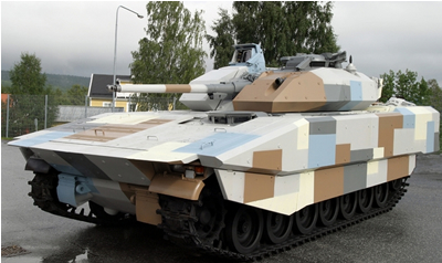
    CV90 AFV / Armor Upgrade

    Export of the BAE Systems Land Systems Hägglunds CV90 Mk II series IFV continues as the vehicle gets new upgrades preparing it for the latest threats. Since entering service with the Swedish Army in 1993 the CV 90 is operated by Norway, Finland and Switzerland. Netherlands became the fifth country to operate the vehicle; the first of 184 ordered will be delivered in 2007. The Dutch configuration will be armed with a 35mm/50mm cannon. At DSEi 05 the vehicle was shown installed with a new modular appliqué armor kit, developed by RAFAEL. The armor suit can be adapted to meet specific threats including mines, horizontal HEAT and kinetic energy (KE) projectiles and top attacks. The vehicle will also be offered with an integrated defensive aid suite, comprising laser warning, radar and missile approach warning. According to Rafael, this new-generation armor is based in part on its new insensitive reactive armor, combined with various types of passive armor appliqués.

    CV90 vehicles are operated by the armies of Norway, Finland, Switzerland, Netherlands and now Denmark. Total orders of CV90s series vehicles including the 4th generation CV9035 MkIII amount to for 1,170, of which 45 are on order by Denmark. The CV9035, built by , is a new-generation CV90, with improved fire power, protection, mobility and ergonomics plus an advanced electronics architecture.

    Dragon Eye Miniature UAV

    Dragon Eye is a five-pound, back-packable, modular unmanned aerial vehicle (UAV) providing organic aerial reconnaissance and surveillance for the US Marine Corps at low tactical units levels. Dragon Eye’s twin electric engines run quietly on battery power. It is flown autonomously at an altitude of 150m’. The total weight of the Dragon Eye is 2.5 kg, of the payload (camera and equipment) weighs 1 pound. The US Marines Corps are planning to procure an enhanced version of Dragon-Eye, known as model X-63.

    The system is carried in a standard backpack, disassembled into five sections and carried with the 5 kg control station. Prior to the mission it is quickly assembled in the field within ten minutes. Dragon Eye is made of lightweight Styrofoam-like materials. It has a 18 cm wingspan once assembled and weighs about five pounds. The missions is programmed on the control station and transmitted to the UAV via wireless modem. The UAV is launched by a bungee cord or by hand. After launch it climbs to the cruise altitude and sweeps through the pre-assigned waypoints, navigating via GPS. The fuselage mounted side looking sensor comprises of a low-light b/w camera, capable of transmitting live video to the ground station from a distance of 10 km, via line-of-sight video datalink. Operator’s training requires less than a week for soldiers to be able to operate them.

    A Dragon Eye system consists of two air vehicles, four cameras, two replacement noses and one ground control station. The target cost at full rate production is approximately $60,000-70,000 per system. Aero Vironment has won the competition to supply the 342 Dragon Eye systems to the USMC from 2004 through 2006. The system is expected to field with initially at battalion and company level and further reach down to the platoon.

    The Dragon Eye is undergoing further development with testing of a high-resolution 640 x 480 infrared camera, development of a communications relay payload, an integrated communications system, and introduction of experimentation with alternate power supplies and air vehicle design to improve endurance. A prototype zinc-air battery developed by Arotech Corp’s Electric Fuel subsidiary has already been tested with the Dragon Eye unmanned drone.

    An enhanced version is currently under development at Aerovironment based on requirements and operational feedback from combat units operating the drone. The Dragon Eye UAV Block Upgrade, also known as X-63 will get air frame modifications and improved power sources increasing its loitering capability. It will have an autopilot for improved landing accuracy and in-flight navigation, and a new sensor payload with an IR and zoom camera that will providing true day/night capability. The system will have a new Level-4 compliant communications control board with 16 software selectable channels for uplink and downlink, twice the current capacity.

    • Air vehicle: 2.5 kg

    • Wing span: 18 cm

    • GCS – 6 kg

    • Endurance: 60 minutes

    • Cruise speed: 65 km/h

    TACMAV

    The Tactical Mini UAV (TACMAV) system is operating with special operations forces, and is currently evaluated by the US Army for deployment with lower echelon units deployed in Iraq. TACMAV system includes three aerial vehicles, modular payloads, and ground control unit and communications equipment. The MAV has a cruising speed of 80 kph.

    The 50 cm long miniature drone has a wing span of 53 cm. It uses flexible wings which can be folded around its fuselage, allowing the entire UAV to be stored in a 56 cm long, 13 cm diameter tube carried soldier’s backpack. When pulled out of the tube, the folded wings automatically snap into place.

    TACMAV uses a payload pod containing two color CCD cameras and a video transmitter, weighing only 40 gram. The total payload capacity of the TACMAV is 80 gram. The user can select forward or side looking camera. 15 frame “snapshots” can be used to recorded target of interest. The battery operated vehicle has an endurance of 30-50 minutes, using rechargeable lithium polymer cells. Higher capacity cells can extend the mission twofold. The GCU is running standard Air Force Portable Flight Planning System (PFPS) interface for mission planning, supporting pre-flight planning, in-flight updates and manual control.

    Miniature Aerial vehicles Design considerations

    Start < Page 4 of 7 >

    Currently available MAV are larger than DARPA’s target platforms, but are already backpackable and operated by a single soldier or a team of two. It is designed to be fully autonomous – and require no special expertise or support at the operational level, at the platoon or battalion. The small drones are built to survive harsh conditions, operate in difficult weather conditions and communicate with their ground systems without the use of sophisticated directional links. The small dimensions dictate the use of lightweight sensors and payloads, based on miniature day or night cameras as well as uncooled infrared systems. Datalinks are maintained as simple systems, as the requirement is for short range operation (10km) directly over the combat area, where enemy electronic countermeasures are not expected.

    Structural Design

    As the design goal of current MAVs is aimed at 10kg weight, the most critical aspect of the aerial vehicle is weight. Therefore, lightweight materials are used extensively to form large assemblies that are easily interconnected to form the aerial vehicle. Future materials in development today will integrate power sources into the structural assemblies, providing “multifunction structures”. In order to reduce weight, various approaches are used, from prefabricated shell, made of durable lightweight composites, to a podded payload, carried by a hollow tube connected, to film laminated wings and tail, as demonstrated by the Skylark miniature UAV designed for Elbit Systems by AD&D. Other approaches are based on inflatable aero dynamic structures, which enable deployment of miniature UAVs from artillery projectiles and rockets. Vertical takeoff and landing systems are also proposed for MAV, utilizing miniature helicopters as well as various ducted fan tail sitters, as demonstrated by Singapore Technologies Engineering (ST Aero) Fantail. Other systems utilize effective aerodynamics to perform a “one way” glide mission, as they are deployed from UAVs, aircraft or guns, over the target. Such expendable MAVs can also be used for attack missions.

    Propulsion and Energy Sources

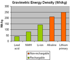
    Most miniature UAVs are powered by electrical motors, which limit their endurance to 1 – 2 hours, enabled by the power density provided by the batteries carried on board. Although internal combustion (piston) engines could provide a good alternative, their noise signature, weight and reliability are not suitable for MAV applications. Current MAVs are using specially designed lithium primary batteries, while new high density zinc-air cells have also been introduced, to offer up to 33% higher density power compared to lithium batteries. Zinc-Air batteries are designed specifically for mini-UAV applications. Developmental items have already been tested with NASA on a micro-UAV, flying a 58 minute mission. Other designs are underway for micro UAVs such as IAI Mosquito, as part of an Israel’s MOD R&D program. Future applications of DARPA’s “palm power” power cells could also be applied to MAVs, offering extended range and endurance.

    Payloads

    Advanced MAV payload weigh from just less than 1 kg to few tens of grams, yet include two or four axis stabilization, and high performance television camera, infrared sensors, mostly those operating in the 3-5 micron range, for day/night surveillance, as well as acoustic sensors. Other sensors can include chemical-biological sensors, and electronic surveillance equipment.

    Mission Control

    The control systems utilized with current MAVs offer “mission control”, rather than “flying” the aircraft like RC modelers do. The operator, usually an infantryman or a special forces warrior, carry a small laptop or palmtop PC, with a ruggedized “joystick, which enable functional control of the payload, and basic mission commands such as “maintain position” or “go to point” and “come home” etc. Mission specific control features also include “convoy protection“, recently demonstrated by MLB.

    All the flight control and auto-pilot functions must be performed autonomously by the aerial vehicle. The MAV must fly itself in calm or harsh weather conditions, including turbulence and wind gusts. Its flight controls include all motion and air data sensors, flight actuators and control surfaces, all driven by the an automatic piloting and control system. Control surface actuators are also driven by electric motors.

    Future applications of micro mechanical components (MEMS), ultrasonic devices and piezoelectric actuators are foreseen for future MAVs. Such components are expected to improve reliability, save weight and reduce overall power consumption. Most MAVs are utilizing Global Positioning Satellite (GPS) data for navigation and positioning. Other sensors required for position sensing include angle rate sensor, pressure, accelerometers, and altimeter, to name only a few .

    Communications & Data-link

    The airborne communications equipment performing video down link and command uplink, is also “hungry” for scarce power resources. The use of miniature, low power high frequency communications, specially designed for such applications, provide an important element in a successful MAV design. As higher the frequencies are, the antennae can be shorter and smaller. Since most MAVs are built of composite materials, antennas can be integrated into the vehicle’s structure to gain maximum coverage and minimize electromagnetic interference between on board radio systems.

    Packaging & Logistics

    While packaging of conventional UAV systems is a secondary logistical consideration, the packaging, assembly and reconditioning of a MAV is an critical aspect for efficient use by the field troops. Several approaches considered for such systems are assembling the aerial vehicle by hand, prior to a mission, firing the drone from a canister, like a missile, or deploying a UAV from a storage/launch cassette. Each of these concepts should enable compact carriage of the entire system in a backpack (drone, ground station and data-links), quick and simple assembly, automatic per-flight testing, and sensor calibration. Systems should also be designed for easy and simple interchanging of structural assemblies, to enable simple and rapid reconditioning of aerial vehicles at the field level.

    Additional parts of this article:

    3D audio for Warrior Programs

    An advanced 3D audio communication systems is developed by a team led by Sennheiser Canada under the Canadian Soldier Integrated Headgear System (SIHS) program. The team also includes AuSIM Inc. from the US and Britain’s Davies Communications from the Selenia Communications group.

    The soldier-worn systems will provide three-dimensional reception of electronic communications and 3D audio cues to enhance situational awareness. 3D audio feature provides spatial information of the incoming call, improving the soldier’s capability to monitor multiple communications channels and prioritize important information as it is received. 3D cues are based on GPS information encoded with every transmission. SIHP monitors the soldier’s head position, decodes the incoming signal, and plays the signal in 3D audio, accurately simulating the source of the signal’s location. The system also function as a navigation guide, triggering audible cues near navigation waypoint, alerting of threat locations and exposure to enemy line of sight etc.

    The SIHS performs as “transparent” system, maintaining the wearer’s natural hearing throughout the use of the system. It also protects the user’s hearing from the damage of loud or impulsive noise, using active noise reduction.

    Advanced Information Architecture

    The US Marine Corps is testing a tightly integrated information network designed to provide warfighters at every level with collaborative, real-time information and imagery. During the “Agile Lion” demonstration, the Corps will test Northrop Grumman’s Advanced Information Architecture (AIA) providing commanders on the ground an access to real-time aerial imagery taken by Litening targeting pods. The digital imagery files will be filed and stored into a dynamic catalog of tactical information including targeting video.

    AIA will be integrated into a variety of Marine Corps tactical platforms, including an AV-8B and an F/A-18D aircraft equipped with a Litening pod, a Cobra attack helicopter, a C-130J air refueling tanker, ground vehicles and even individual Marines, which will allow them all to share tactical information in real time. “The tanker will be equipped with an AIA suite enabling it to expand its role of aerial refueling to ‘digital refueling,'” said Dale Burton, sector vice president and chief technology officer for Northrop Grumman’s Integrated Systems sector. “In Northrop Grumman’s Brilliant Constellation concept, digital refueling means delivery and sharing of information and situational awareness products between warfighters, in the cockpit or on the ground, via its real-time network.”

    A Command Operations Center (COC) at Marine Corps Air Station Yuma has also been equipped with a ground-based AIA command node to provide data access, chat and e-mail capability so that ground forces can exchange information with the COC without using voice
    communications. Marine Corps ground units will use personal-data assistants and laptop computers to access data provided through the AIA network.

    “Our goal in Agile Lion is to show the value of tactical, ad-hoc networks that enable both air- and ground-based warfighters to collaborate in real time, especially while on the move,” said Burton, “Today, most of the raw data collected by tactical assets is available only in cockpits and command centers. The demonstration of AIA in Agile Lion will highlight how forces in convoys and dismounted Marines can ‘pull’ or ‘push’ data-imagery, signals, intelligence, chat, e-mail or other information-to and from a network of airborne and ground-based servers, allowing real-time collaboration among users.”

    Automated Deep Operations Coordination System – ADOCS

    The Automated Deep Operations Coordination System (ADOCS) is one example of a joint mission management software application. The concept originated as a DARPA Program and evolved into the “go to war” automated support system for deep operations in several theaters. The US Army is using over 5,000 such systems worldwide.

    ADOCS is also a major segment of the intelligence application package for Theater Battle Management Core System (TBMCS) functionality at wing and squadron level. Deployed to the smallest detachments and all the way up to the Combined Joint Task Force Headquarters, ADOCS shares a Common Operational Picture through all users. The system enables joint planning, coordinating, and executing with horizontal and vertical integration across the joint battle space.

    Enabling the service level commander and staff to allocate critical air resources in an efficient way, the Air Tasking Order (ATO) planning and execution tools are optimizing the employment air assets, improving the flow of information for identification, assignment, and nomination of targets. The process provides early assessment of potential and planned missions. The center monitors ATO execution through all phases and provides immediate visibility into air nominations throughout the targeting process, including distributed 8- and 4-hour updates to allow for detailed target validation prior to strike. ADOCS also supports analysis to assess the changes and movements of the Fire Support Coordination Line (FSCL) on current and planned missions in the ATO. It provides immediate visibility of targets exposed or covered by movements in the FSCL. Situational awareness is provided by battlespace visualization functions to support faster, accurate deep attack planning, and battle space assessment. Tools provide visualization of coordination measures, ingress and egress routes, and air defense threats. Friendly fires are shown in 3D space over any area to effectively deconflict dangerous situations. Battlefield geometries can also be overlaid with imagery and terrain data to improve situation awareness and planning. No Strike List (NSL) and Restricted Targets List (RTL) are constantly referenced in all phases of mission development to eliminate potential to collateral damage and fratricide.

    Key integration functions within ADOCS are Joint Time Sensitive Target management, The Joint Time Sensitive Targets Manager (JTSTM) in ADOCS allows for target creation, vetting, coordination, and execution across the Joint Command structure. It is tailored to allow the Region Combatant Commander to use all of the weapons systems in the joint battle space to engage time sensitive targets. Another feature of ADOCS is the Intra-Air Operations Center Targets Management (ITM), provides a tool for the Air Operations Center (AOC) to coordinate and engage those targets which have a significant impact on the conduct of the air battle. The ITM allows the users to coordinate, deconflict, match aircraft to the target, and submit to Theater Battle Management Core System (TBMCS) the request for a change to the Air Tasking Order (ATO). The digital coordination and deconfliction features of this manager greatly reduce detect to destroy times for AOC critical targets. The ITM is also capable of linking its mission data to the Joint Time Sensitive Target (JTST), Intelligence Surveillance and Reconnaissance (ISR), and Fires managers in ADOCS for joint visibility and engagement.

    ADOCS supports coordination of certain air space through it is Airspace Coordination Request (ACR) manager. The ACR Manager can conduct time and altitude, zone and corridor deconfliction. ADOCS also allows air space requests to be modified and coordinated across boundary lines and through the echelons. The ACR manager is also seamlessly integrated with the Tactical Airspace Integration System (TAIS) for airspace management and visibility. ADOCS can display the Airspace Control Order (ACO) from both TAIS and TBMCS and constantly compares missions against the protected airspace to alert the users of potentially dangerous conflicts. The Combat Search and Rescue (CSAR) manager in ADOCS allows the local rescue coordination center to plan, coordinate, and execute search and rescue operations across the joint battlefield. By consolidating all of the critical information elements into an in-depth mission roll-up, the agencies involved in Personnel Recovery are able to view and track the progress of the recovery operation. ADOCS uses the ATO to automatically recommend recovery assets for direct pairing with a particular mission. The CSAR manager also allows dynamic tasking of other assets to assist in the recovery operation.

    ADOCS contains mission managers that allow the user to coordinate and execute indirect fires including tube artillery, multiple launch rocket systems, ship fired missiles, and coordinated engagements on seaborne Special Operations Forces. Not only does ADOCS have the ability to weapon-target pair and begin the engagement process, it always performs conflicts checks against the targets to ensure there is no unnecessary collateral damage or fratricide. The system supports Counterfire Common Operational Picture (CF-COP) functions providing a near real-time picture of the artillery battle. It allocates tube and rocket counter-battery resources for more efficient counterfire operations through digital integration at multi-echelons; from joint/combined level down to tactical firing units. CF-COP also includes munitions allocation and weapon system status. Weapon-target pairing provides improved use of available munitions to maximize lethality while conserving time and munitions for follow-on engagements.

    The Intelligence, Surveillance, and Reconnaissance Manager in ADOCS allows the intelligence community to coordinate multiple collection platforms in a synchronized collection effort on the target. Following the cross-queue collection effort, ADOCS has the ability to pass the mission to its other target execution managers. Similarly, the JTST and ITM managers in ADOCS can send missions to the ISR Manager for detailed collection prior to determining the execution course of action.

    Faust (FIST) Battle Management System

    After parallel development of two Army C2 systems designated GeFuSys and FuWES-Kern H, the two programs were integrated into the C2 system currently known as “Faust” (Fahrungsausstattung Taktische). Faust was further designed to be integrated into the division level and army-wide FuInfosys H C4I system. the tactical C2 system, was deployed in 2003 with a battalion-size Battle Group West, part the allied forces in Afghanistan (ISAF). Since June 2004, Faust was introduced for operational evaluation the German elements in the peacekeeping forces in KFOR, SFOR and has been cleared for operational use in February 2005.

    Faust is designed with modular elements, which can implement new modules, regular upgrades and local adaptations to the basic system. Each Faust unit is linked to a vehicle and transmits its own GPS position to the network. The basic service provided by the system are the geographic information display (GIS) map display and “Blue Force Tracking”, monitoring all friendly elements in the area over a digital map, and providing commanders with common and updated operational picture. Other services include secure messaging, communications management and control and general office automation functions. Monitoring all activities and resources over a digital map dramatically improves the utilization of assets, reduces voice communications and generally improves command and control. This function also supports an “emergency call” which transmits the vehicle’s position and emergency alert which flashes on the recipients’ map. Faust was developed by EADS Deutchland GmbH.

    Faust has been integrated with a wide range of communications systems. Primary terrestrial communications were provided by VHF (combat net radios) and GSM (commercial cellular networks). Satellite communications were also provided during testing and expeditionary deployments. The system can also utilize terrestrial lines using ISDN/AUTAOKO 90 protocol. Following the decision by the German Ministry of Defense to field Future introduction of Tetrapol military communications systems will be required in the future.

    The GIS and mapping functions support different scales of maps, as well as on-screen position, range and area measurements, path finding, perspective views etc. The system provides automated task organization. Tasks can be displayed in a “tree” form, enabling “drag and drop” of elements between various units for. Every change is reflected in the relevant unit’s organization, and “to do” list.